

Several books contain good sketch maps of the Triangle but I find that it is always difficult to have a real sense of scale and distances with highly simplified maps. Thankfully, we have three things to be thankful for when trying to get a better handle on the lay of the land in Hue: the pervasive use of helicopter in Vietnam, the development of cheap Japanese cameras and the National Imagery and Mapping Agency. As a result, there are some very clear aerial photographs of the city and an absolutely gorgeous 1/12500 map of Hue from 1968 which is reproduced in the Perry-Castañeda Vietnam map collection and can be freely downloaded (warning: it is a 12MB file). The map identifies major structures all over the city but sadly, the guide to numbered features which was printed on the reverse isn't available.
Reproduced below are two of these aerial photographs, on which the numbered features from the NIMA map have been added. I have tried not to obscure the buildings but the original photos are also reproduced at the bottom of this post, along with a larger extract from the map.
Note: all the images on this page can be expanded to their original size by right clicking and opening either the image or the link in a new tab.
One thing which these aerial photographs vividly illustrate is the extremely up close and intimate nature of the block to block fighting where simply crossing a street to assault a small group of buildings became a hugely difficult undertaking.
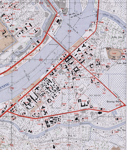 |
| Extract from 1:12,500 Hue map, Edition 3-AMS (29 ETB), Series L909, National Imagery and Mapping Agency, 1968 |
 |
| Aerial photograph of Hue, ca. 1965, copyright unknown |
Note: in this early photograph, the MACV Compound (8) lacks the personnel accommodation and the chapel which was built to the south-east of the two buildings.
 |
| Aerial photograph of Hue, 1968 (post Tet), copyright unknown |
 |
| Aerial photograph of Hue, 1968 (post Tet), copyright unknown |
8: Military Assistance Command Vietnam (MACV) compound
24: LCU Ramp
44: Esso Gas Station
50: Post Office
51: Thua Thien Province Prison
52: Public Health Offices
57: Notre-Dame-du-Perpétuel-Secours Cathedral (Nha Tho Duc Me Hang Cuu Giup), just South of the road across from 57
65: Thua Thien Province Headquarters
66: Police Compound
70: Treasury
72: US Consulate
73: US Consul's Residence
81: Antituberculosis Centre
101: Hue City Officers Mess (Closed)
102: Le Lai Military Camp
111: Chemistry Lab and Music Room
133: Doc Lao Parc
134: French Cultural Centre
143: Cercle Sportif
149: Tự Do Stadium (Freedom Stadium)
171: Saint-François-Xavier (Phanxicô Xaviê) Church
179: Hue Municipal Power Station
186: Hospital Training Centre
187: University administration building
189: Hue University Library
191: Jeanne d'Arc High School
192: Le Loi Elementary School
210: Phu Cam Church
222: Student Centre
Below
are the original unnumbered photos and a larger extract from the Hue
map (click to enlarge).
 | |
| Extract from 1:12,500 Hue map, Edition 3-AMS (29 ETB), Series L909, National Imagery and Mapping Agency, 1968 |
 |
| Aerial photograph of Hue, ca. 1965, copyright unknown |
 |
| Aerial photograph of Hue, 1968 (post Tet), copyright unknown |
 | |
| Aerial photograph of Hue, 1968, copyright unknown |
UPDATE
Finally, an update after all these years. Below is the missing key to the locations which was printed on the reverse of the map (from the National Archives Catalog). Some of these locations do not match my best guess above so I'll revisit some of them at some later date.


do you have the full numbers list?
ReplyDeleteNope, never found it. Still have my fingers crossed though...
ReplyDeleteAre you still active? I've finally got the full map with the list
DeleteActive would be exaggerated but I do pop around once in a while. I'd be very interested to see the full list. The complete map is linked to at the beginning of the post.
DeleteThere was a ESSO service station on the south corner MACV compound ?
ReplyDeleteDuy Tan Hotel retained the gates and the main building of Jean arc School
Do you have any further info on the location of a second ESSO station closer to the MACV compound? I've got a photo that includes part of an ESSO sign, but the location doesn't match to #44 above.
DeleteIt was on the north east corner of Nguyen Tri Phuong Street and Duy Tan Street. I have multiple photos and video of it if you want.
DeleteHey Cap, id be very interested in the full map and well anything on Hue
ReplyDelete